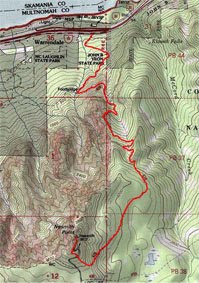
On Friday (4/22) I joined my friend Nate to hike up to Nesmith Point on Oregon's side of the Columbia Gorge. At 3,810 feet, it's the highest point along the promontories overlooking the river. Mt. Defiance and several other peaks are taller, but are set back and invisible from I-84 and the historic Columbia River highway. The hike is generally considered by the guidebooks as difficult for its 3,700 feet of elevation gain and a roundtrip distance of nearly 10 miles.
The weather was nearly perfect as we left Nate's house in southeast Portland around 8:30 a.m. and drove out along I-84 to the trailhead. The mighty Columbia near Vista House and Rooster Rock looked like a pane of glass while a few ospreys soared overhead, riding a mid-morning thermal layer. We both commented that it had been awhile - if ever - that the river appeared so tranquil.
We originally planned to hike Table Mountain on the Washington side of the river, but called an audible when we noticed snow clearly visible on its southern flanks. Table is steep enough in a few places to make the hike quite treacherous in the snow without the proper gear.
The trailhead for Nesmith Point is at John B. Yeon State Park directly across the Columbia from Table and Hamilton Mountains. When we arrived only two other cars were in the parking lot - a welcome sign to what promised to be a sunny day. Parking can often be difficult to find on the Gorge's more popular hikes, especially on the first nice day of spring.
 We hit the trail just after 9:00 a.m. into the forested area at the base of the ridge. Nate tried - somewhat in vain - to educate me on the flora and fauna of the region. Despite my knowledge of arcane geographic and historical facts, I'm a dunce when it comes to identifying trees, ferns, woodpeckers and other life in the woods. Nate kindly tolerated me referring to each tree as a Douglas Fir (generally a safe guess in the Cascades) when they were actually cedars, hemlocks or something else altogether.
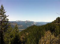 As the trail switch-backed through the woods, we caught glimpses of Beacon Rock and Hamilton Mountain on the Washington side of the Columbia. The sun had yet to crest the ridge we were ascending, giving the light on the volcanic rocks an ethereal beauty. In a few places the terrain looked like something from the New Zealand set for the Lord of the Rings trilogy. Regrettably I left my Nikon SLR and point-and-shoot cameras at home and was left with my third-string option - my iPhone - to document the occasion. It did just fine filling in off the bench, but I don't plan to make the mistake again.
We continued pushing onward for a few miles up the switchbacks. For the most part the trail was impressively well-maintained, but the drop-off was frequently severe. We both used caution to avoid a tragic misstep. With the increased elevation came even more impressive views of the river and surrounding landscape. We stopped more than once to soak in the view of Table Mountain with Mt. Adams in the background.
 The guidebooks tell you the trail to Nesmith Point is typically snow free by April. However this April was far from typical. About three miles in we hit the snow we had tried to avoid by climbing Nesmith over Table. It would remain with us for the remainder of the hike. Dangerously slippery in some places, slightly powdery in others, the snow dramatically changed the look and feel of the hike. Fortunately we both brought hiking poles - without them we probably would have turned back.
Soon after hitting the snow, the trail leveled out at the top of a ridge. We then traversed the relatively flat ridgeline for over a mile towards the summit. The first warm weather of the season caused chunks of ice to fall from the trees and pelt us on the head and send icy discomfort down our necks. After plodding along for what seemed like an hour we stopped to check the guidebook. Sure enough, we seemed to be going the right way.
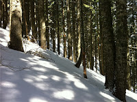 The trail then began to steepen substantially. The snow caused us to accidentally deviate from the actual path and led us to carve our own route up the slope and through the woods to the summit. Finally we could climb no higher and reached the rock marking Nesmith Point.
The view was spectacular. Trees prevented us from seeing a full 360 degree view, but to the west we could see the arc of the Columbia running past PDX airport and up towards the towns of Scappoose and St. Helens. The skyscrapers of downtown Portland, the West Hills and even the edge of the Coast Range were all visible.
Here's a video of the view from the summit:
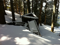 We took some pictures, admired the ruins of the outhouse that used to provide an epic throne to hikers more than a generation ago and devoured trail snacks. Although the sun was out, it was still chilly at the summit and we decided to move on after ten minutes.
With the promise of fried food and fermented drink awaiting us in Cascade Locks, we bolted the five miles back to the car. The descent seemed to go much faster - there's nothing like the motivating power of cold beer and a good meal. We passed four people and a dog on the way down, but otherwise didn't encounter anyone the entire day.
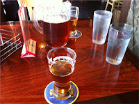 In half the time it took us to climb up, we were back to the switchback part of the trail. By now the light was much different than in the morning and the sun had crested over the ridge that was now at our backs. We paused a few times to appreciate the splendor of the Gorge, but otherwise moved at speed down the trail. Once the path leveled out we ran the last half mile or so back to the car. We were at the Pacific Crest Pub ten minutes later with an IPA in hand five minutes after that.
Overall the day rated as a high nine or even a ten. Great weather, conditions and company combined with almost no one else on the trail is the most you can ask for in a hike.


